If you’re a surveyor evaluating CAD software, here’s the math that gets ignored in every…
CHCNAV RS7: A Faster Way to Collect Field Topo
The short version. The CHCNAV RS7 handheld SLAM scanner gives survey crews a different way to collect topographic data. Instead of stopping to shoot every curb, grade break, pavement edge, structure, and site feature individually, you walk the site and capture a dense 3D point cloud of existing conditions. Back in the office, you extract the topo information needed for your survey deliverable. The RS7 doesn’t replace your GNSS rover or total station. It complements them by making detailed topographic collection faster, more complete, and less dependent on deciding which individual shots to take in the field.
Five Minutes in a Parking Lot
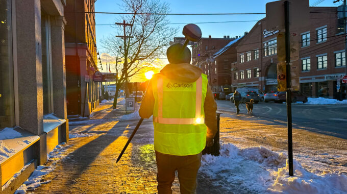
We took the RS7 to a parking lot between commercial units and walked the site for about five minutes. In that single pass, we captured a dense 3D record of the pavement, curbs, building faces, and surrounding site features. No instrument setups, no backsights, and no stopping every few feet to collect another individual topo shot. For a conventional topographic survey, that same area could require numerous individual observations to adequately represent pavement elevations, curb lines, changes in grade, building corners, and other existing conditions. With the RS7, we collected the site first. The decisions about which features and elevations to extract could be made later, in the office, with the full point cloud available for reference.
That’s the real value of the RS7 for field topo: capture the existing conditions now and extract the information you need later.
Stop Picking Every Topo Point Individually
Traditional topographic collection requires constant decisions in the field. Do we have enough elevations to represent this parking lot? Did we collect both the top and bottom of the curb? Was that grade break significant enough to warrant another shot? Did we pick up everything around the drainage structure? Those decisions take time, and missed information can mean another trip to the site. The RS7 changes the collection process. Rather than occupying each individual feature with a rover or total station, the operator walks the site while the scanner continuously collects measurements. Its 64-channel LiDAR sensor provides a 360° × 189° field of view, collecting up to 576,000 points per second in single-return mode or 1,152,000 points per second in dual-return mode. With a specified range of 40 meters at 10% reflectivity, it’s well suited to close- and mid-range site detail collection.
One walk can document:
- Pavement surfaces and changes in grade
- Top and bottom of curb
- Sidewalks, ramps, and pedestrian areas
- Parking islands, pavement edges, and striping
- Building footprints and exterior features
- Drainage structures and other visible utility features
- Retaining walls, steps, and other hardscape
- Visible terrain features and grade breaks
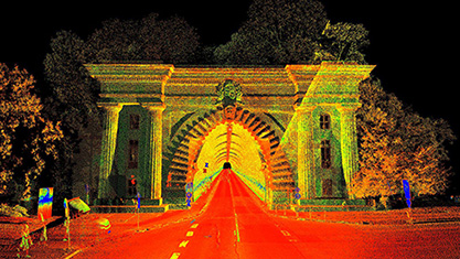
Instead of leaving the field with only the points you chose to measure, you return with a much more complete representation of the site. That matters when you’re building an existing-conditions survey, generating a surface model, preparing contours, or developing a base drawing for engineering design.
Better Topo Starts With More Complete Field Coverage
One of the biggest challenges in topographic surveying isn’t necessarily measuring an individual point. It’s deciding whether you’ve collected enough points to accurately represent the surface. A conventional topo survey relies on selected elevations, breaklines, and feature shots. A good field crew knows where those points belong, but the quality of the resulting surface still depends on what was collected. The RS7 gives the office a dense source of measured surface information rather than a limited set of field-selected points. That can be particularly useful on sites with complex pavement grading, numerous curb transitions, drainage features, loading docks, parking islands, and irregular hardscape. Need another elevation along a pavement transition? The information may already exist in the scan. Need to trace a curb that wasn’t originally identified as important? It may be recoverable from the point cloud. Need additional terrain detail to improve a surface? You can evaluate the captured ground points without automatically sending someone back to the field. The scanner doesn’t eliminate the need for survey judgment. It moves much of that judgment into the office, where the entire dataset can be reviewed. And it gives the person preparing the drawing more information to work with.
Check Your Coverage Before Leaving the Site
SmartGo NEO provides real-time point-cloud visualization during collection, along with playback preview. For topo work, that means the operator can evaluate coverage before leaving the property. You can identify areas that may need another pass, check for gaps caused by vehicles or other obstructions, and verify that critical portions of the site were scanned. That is especially valuable on busy commercial properties, parking lots, industrial facilities, and other locations where access may be limited. The goal isn’t simply to collect more points. It’s to leave the site with the information needed to complete the existing-conditions drawing.
Survey Accuracy Still Matters
CHCNAV specifies relative accuracy better than 1 cm and repeatability better than 2 cm under laboratory conditions, along with absolute accuracy better than 3 cm RMS horizontally and vertically under specified favorable GNSS conditions. Those numbers need to be understood in context. SLAM scanning, like any other measurement technology, has limitations. Trajectory drift, GNSS conditions, obstructions, surface characteristics, and processing methods can all affect the accuracy of the resulting point cloud. The RS7 integrates GNSS, inertial navigation, and SLAM positioning to support continuous scanning in a variety of environments, including areas where satellite reception is limited.
But a dense point cloud is not automatically a controlled topographic survey.
For survey-grade work, conventional control remains essential. Establish or recover control with GNSS and total station equipment, incorporate surveyed reference points or targets into the scanning workflow, and verify the resulting cloud against independent check measurements. Critical elevations and features should still receive the measurement and verification appropriate to the project. The practical workflow is straightforward: use your conventional instruments to establish the survey framework, then use the RS7 to efficiently collect the surrounding topographic detail. That way, you gain the production benefits of scanning without abandoning the measurement practices that make a survey dependable.
Where the RS7 Makes the Most Sense for Topographic Surveys
The RS7 is especially attractive on sites where the number of features and surface changes makes conventional point-by-point collection time-consuming.
Commercial parking lots and retail properties. Capture pavement grading, curb lines, islands, sidewalks, entrances, ramps, and building exteriors without individually occupying each feature.
Industrial facilities and equipment yards. Document hardscape, loading areas, concrete pads, retaining walls, drainage features, and other existing site conditions where dense detail is useful.
Roadways, drives, and paved corridors. Collect continuous pavement and edge-of-pavement information, curb transitions, sidewalks, and visible grade changes for mapping and design work, subject to access and safe collection procedures.
Site development and engineering design surveys. Supplement conventional topo observations with dense coverage of existing conditions that can be used to prepare surfaces, contours, profiles, and design base maps.
Building exteriors and as-built surveys. Capture building faces, steps, ramps, entrances, foundations, and adjacent site grading in the same dataset.
Interiors and enclosed structures. The same equipment can document rooms, corridors, stairwells, mechanical spaces, basements, and other areas where conventional setups or GNSS collection are difficult.
There are limitations. Vegetated terrain can complicate ground extraction, parked vehicles can obstruct surfaces, and critical features may require supplemental conventional shots. Not every project benefits equally from scanning. But on detail-heavy sites with substantial visible pavement, concrete, hardscape, and structural features, the RS7 offers a compelling alternative to collecting every topo shot one at a time.
From Point Cloud to Finished Topo in Carlson
Capturing the site is only the first half of the job. The value comes from turning that data into usable CAD geometry, surface models, contours, and other survey deliverables. The RS7 workflow begins with SmartGo NEO in the field, followed by processing through CHCNAV CoPre for trajectory processing, adjustment, refinement, and point-cloud generation. CoCloud provides an additional cloud-processing option. Once processed and brought into the appropriate survey coordinate system, the point cloud can be used in Carlson Point Cloud. For surveyors already working in Carlson, this creates a practical path from field scanning to finished topographic drawings.
Carlson Point Cloud supports:
- Extraction of curbs, sidewalks, pavement markings, building outlines, and other site features
- Filtering of point clouds to identify bare-earth surface information
- Generation of contours and terrain models
- Creation of profiles and cross sections
- Volume calculations and surface analysis
- Integration of extracted features and surface data into CAD-based survey and engineering workflows
Carlson Point Cloud Advanced adds automated feature extraction, additional filtering and transformation tools, and the creation of feature-type points and solids. This is where the RS7 becomes more than a scanning instrument.
It becomes a field topo collection tool feeding an existing survey-to-CAD workflow.
Your crew collects the site efficiently. Your office extracts the necessary features, develops breaklines, evaluates the surface, and produces the deliverable. Not every point in the cloud belongs in the drawing. The advantage is having the source information available to select the points and features that do.
A Different Way to Think About Field Production
The traditional workflow is built around choosing the right points to collect while you’re in the field. The RS7 offers another approach: collect a dense record of the site, then select and verify the measurements required for the finished topo. That doesn’t make conventional survey instruments obsolete. In fact, the strongest workflow combines the technologies.
GNSS and total stations establish control and verify critical measurements. The RS7 captures dense site detail. Carlson turns that information into usable topographic deliverables.
For crews spending substantial field time collecting hundreds of individual elevations and feature shots on detail-heavy sites, that’s a workflow worth evaluating. The benefit isn’t just faster collection. It’s more complete coverage, greater flexibility in the office, and fewer opportunities to discover that a needed feature was never measured.
Want to See How the RS7 Performs on a Topo Job?
We’ve tested the CHCNAV RS7 ourselves, and we can help you determine whether it fits your topographic survey workflow. Whether you’re collecting existing conditions for engineering design, mapping commercial properties, documenting industrial sites, or looking for a more efficient way to handle detail-heavy field topo, we’d be happy to show you what the RS7 can do.
Call 1-888-299-6996 or email info@carlson-us.com.
Explore the CHCNAV RS7 | Carlson Point Cloud | Carlson Field Instruments

Related Posts